NV Charts GPS Navigation AIS 2.714.192
Free Version
Publisher Description
NV Charts GPS Navigation AIS - NV Charts App is an ideal tool to navigate with NV Charts cartography.
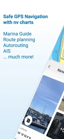
The NV Charts navigation app with an intuitive interface and powerful tools is a must-have for onboard navigation while cruising, fishing, sailing, diving or any other activity on the water. All current editions of the boating charts or maps from NV Charts can be easily downloaded and used for offline navigation with the NV Charts App. All latest editions of NV Charts nautical boating charts or inland charts including | North Sea | Baltic Sea | Netherlands | Wadden Sea | IJsselmeer | Sweden | Denmark | Germany | Norway | France | USA | Caribbean | Bahamas areas are compatible with NV Charts App.
One way to have great nautical charts both on paper and on our phone or tablet is to use our popular combination pack of paper and digital nautical charts, which includes both charts in clever atlas format and a license for digital nautical marine boating charts/maps for use in the NV Charts App, including an update service. The advantage: Both your paper and digital charts are up to date.
In addition you can also purchase digital boating charts as a subscription directly in the NV Charts App. The subscription duration is one year and is automatically extended.
If it is not yet clear where the journey is going to take you, free online charts can be displayed in the app, even without a current subscription or valid paperchart edition.
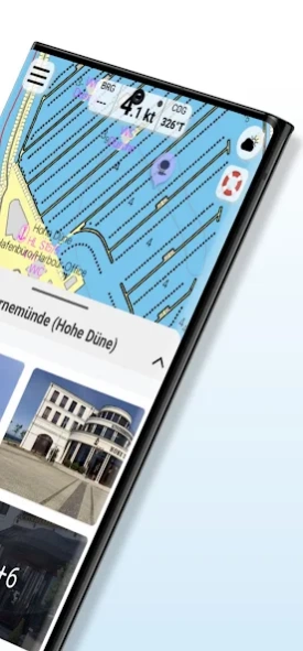
The latest information is essential for safe navigation on the water. With the NV Charts App you have the possibility to become part of the Seame boating community. You can now add marinas, anchorages and navigation warnings to the digital chart and also add and share interesting places beyond navigation, such as restaurants or points of interest with pictures. Others can respond directly with comments. The continuously edited content can be downloaded directly to be available offline. In order to make all information easily accessible, we have improved the search function: You can explore the surroundings and search directly for place names as well as anchorages, harbours, ramps, waypoints, cranes, petrol stations, or tide stations. In addition, an auto-routing function has been integrated, which allows you to navigate directly to your destination.
Together navigation on board is even more fun! You can now share your tracks with friends or use the data outside the app and export it as GPX file. You can share your favorite harbours and anchorages from the app simply by clicking on a link and coordinate your trip planning even better with everyone.
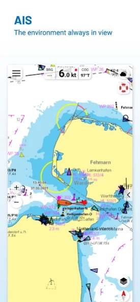
With the AIS function in the NV Charts App you can keep an eye on AIS signals in real-time. You can connect a Wlan AIS receiver to the NV Charts and the app display AIS Class A and B signals and navigation aids (ATON), as well as MOB AIS SART transponder distress transmitters, directly in the digital chart in real-time and the traffic situation can be assessed better.
The NV Charts App can be installed and synchronized on multiple devices.
NV Charts App - Features:
✔ Search function
✔ Autorouting (Europe + other regions following soon)
✔ Velocity Made Good (VMG)
✔ Community Layer / Points of Interest(POI)
✔ Free online boating charts preview for planning
✔ In App Purchases of digital offline charts
✔ Community Layer / Points of Interest(POI)
✔ Reads all NV Chart chart areas
✔ Easy download of the maps
✔ Always the latest data
✔ Seamless zoom and panning functions
✔ Tide Forecast
✔ Online weather
✔ AIS Wifi Support
✔ AIS Sart Beacon
✔ AIS CPA function
✔ Night mode
✔ Anchor alarm
✔ Position with GPS
✔ Intuitive route planning
✔ Course markings, markings, bearing ruler
✔ Port information
✔ Display of instruments
✔ Synchronizing devices
✔ Live Position Sharing
✔ Social sharing of routes, tracks, positions
## Android version 7.0 or higher required.
Note:
Continued use of GPS in the background can significantly reduce battery life. For hardware compatibility see FAQs on our website
About NV Charts GPS Navigation AIS
NV Charts GPS Navigation AIS is a free app for Android published in the Geography list of apps, part of Education.
The company that develops NV Charts GPS Navigation AIS is NV CHARTS. The latest version released by its developer is 2.714.192. This app was rated by 2 users of our site and has an average rating of 2.3.
To install NV Charts GPS Navigation AIS on your Android device, just click the green Continue To App button above to start the installation process. The app is listed on our website since 2023-09-02 and was downloaded 304 times. We have already checked if the download link is safe, however for your own protection we recommend that you scan the downloaded app with your antivirus. Your antivirus may detect the NV Charts GPS Navigation AIS as malware as malware if the download link to com.plongo.nvcharts is broken.
How to install NV Charts GPS Navigation AIS on your Android device:
- Click on the Continue To App button on our website. This will redirect you to Google Play.
- Once the NV Charts GPS Navigation AIS is shown in the Google Play listing of your Android device, you can start its download and installation. Tap on the Install button located below the search bar and to the right of the app icon.
- A pop-up window with the permissions required by NV Charts GPS Navigation AIS will be shown. Click on Accept to continue the process.
- NV Charts GPS Navigation AIS will be downloaded onto your device, displaying a progress. Once the download completes, the installation will start and you'll get a notification after the installation is finished.
